
热门标签
热门文章
- 1win11出现安全中心空白和IT管理员已限制对此应用的某些区域的访问_win11被it管理员限制的原因
- 2Docker部署MinIO对象存储服务器结合内网穿透实现远程访问
- 3【愚公系列】2023年12月 Java教学课程 213-ElasticSearch(数据聚合、数据补全、数据同步)
- 4【2023 英特尔On技术创新大会直播 |我与英特尔的初次相遇】—— AIPC探索下一代的物联网时代
- 5计算机教师招聘笔试总结_大专计算机老师笔试
- 6基于Python的Selenium详细教程_pycharm安装selenium
- 7鸿蒙(HarmonyOS)应用开发——从网络获取数据(题目答案)_web组件onconfirm(callback: (event?: { url: string; m
- 8MacBook安装Golang Oracle数据库驱动程序_“libclntsh.dylib.19.1”不是来自app store的app。
- 9【记录】vue-cli+element-ui 制作一个侧边栏组件(抽屉Drawer)_vue3+抽屉
- 10基于Elasticsearch + Fluentd + Kibana(EFK)搭建日志收集管理系统_kibana fluentd
当前位置: article > 正文
雷达3D点云数据转2D激光数据_rslidar 三维点云转换为二维激光雷达
作者:小丑西瓜9 | 2024-02-16 18:51:47
赞
踩
rslidar 三维点云转换为二维激光雷达
步骤:
1.安装:
-
安装rslidar驱动,参考:https://www.ncnynl.com/archives/201807/2552.html
-
编译pointcloud_to_laserscan源码
-
假设工作空间为rslidar_ws
- cd ~/rslidar_ws/src
- git clone https://github.com/ros-perception/pointcloud_to_laserscan
- cd ~/rslidar_ws
- catkin_make
- source ~/.bashrc #假设你已经把工作空间添加到bashrc文件
- 新建rslidar.launch
- cd ~/rslidar_ws/src/pointcloud_to_laserscan/launch
- vim rslidar.launch
- 内容如下:
- <?xml version="1.0"?>
- <launch>
- <!-- run pointcloud_to_laserscan node -->
- <node pkg="pointcloud_to_laserscan" type="pointcloud_to_laserscan_node" name="pointcloud_to_laserscan">
-
- <remap from="cloud_in" to="/rslidar_points"/>
- <remap from="scan" to="/rslidar/scan"/>
- <rosparam>
- # target_frame: rslidar # Leave disabled to output scan in pointcloud frame
- transform_tolerance: 0.01
- min_height: -0.4
- max_height: 1.0
-
- angle_min: -3.1415926 # -M_PI
- angle_max: 3.1415926 # M_PI
- angle_increment: 0.003 # 0.17degree
- scan_time: 0.1
- range_min: 0.2
- range_max: 100
- use_inf: true
- inf_epsilon: 1.0
-
- # Concurrency level, affects number of pointclouds queued for processing and number of threads used
- # 0 : Detect number of cores
- # 1 : Single threaded
- # 2->inf : Parallelism level
- concurrency_level: 1
- </rosparam>
- </node>
- </launch>

- 参数说明:
- min_height 、max_height #这两个参数用来指定这段z轴高度范围内的输入点云将参与转换,范围外的不参与
- angle_min、angle_max #这两个参数用来指定这段yaw角度范围内的输入点云将参与转换,范围外的不参与
- angle_increment #输出的2d雷达数据的角分辨率,即相邻扫描点的角度增量
- scan_time #扫描时间,即话题的发布周期
- range_min、range_max #这两个参数用来指定输出数据的有效距离,即2d雷达的有效测量范围
2.测试:
- 新开终端,启动雷达
roslaunch rslidar_pointcloud rs_lidar_16.launch
-
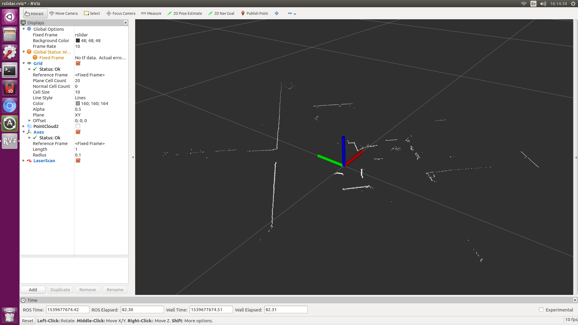
打开rviz,显示3D点云图
-
如图:

-
新开终端,启动转换
roslaunch pointcloud_to_laserscan rslidar.launch
- 在rviz中勾掉pointcloud2
- 增加话题,/rslida/scan
- 如图:
声明:本文内容由网友自发贡献,不代表【wpsshop博客】立场,版权归原作者所有,本站不承担相应法律责任。如您发现有侵权的内容,请联系我们。转载请注明出处:https://www.wpsshop.cn/blog/article/detail/96215
推荐阅读
- 官方说明:XXL-JOB是一个轻量级分布式任务调度平台,其核心设计目标是开发迅速、学习简单、轻量级、易扩展。现已开放源代码并接入多家公司线上产品线,开箱即用。通俗来讲:XXL-JOB是一个任务调度框架,通过引入XXL-JOB相关的依赖,按照... [详细]
赞
踩
- importrepass@property@property@property#正则表达式定义了要去除的标点符号self,)->dict:#自定义的BLEUSCORE评估器。_langfuselangfuse课程学习自知乎知学堂https:... [详细]
赞
踩
- Docker容器作为一款风靡的容器管理工具,已经在生产开发中广泛使用,本节内容以docker容器为基础,安装搭建docker容器的可视化平台Portainer,实现docker容器服务的可视化管理。_docker可视化管理平台docker可... [详细]
赞
踩
- 必读好文推荐:Unity协程(Coroutine)原理深入剖析Unity协程(Coroutine)原理深入剖析再续上面的文章说得太透彻,所以这里就记一下自己的学习笔记了。首先要说明的是,协程并不是线程,协程是运行在主线程中的,是和主线程同步... [详细]
赞
踩
- 1.matlab中如何将点连成线例:plot(x,y1,'o',x,y2,'+',x,y3,'x',x,y3,'*');这个指令表示以标记点'o','+','x','*'分别画(x,y1),(x,y2),(x,y3),(x,y3),即标记方... [详细]
赞
踩
- matlab曲线拟合(3):lsqcurvefit函数_matlab中三个变量怎么拟合matlab中三个变量怎么拟合一、利用lsqcurvefit函数进行自定义拟合函数一般形式f=lsqcurvefit(fun,x0,xdata,ydata... [详细]
赞
踩
- article
windows10 显卡GTX1050安装tensorflow-gpu教程以及Tensorflow不同版本要求与CUDA及CUDNN版本对应关系(GPU版本)_gtx1050 tensflowcuda
windows10显卡GTX1050安装tensorflow-gpu教程以及Tensorflow不同版本要求与CUDA及CUDNN版本对应关系一、安装准备与对应信息二、安装anaconda三、安装cuda9.0四、安装cuDNN五、安装te... [详细]赞
踩
- 一、使用tf.Variable函数创建变量tf.Variable(initial_value=None,trainable=True,collections=None,validate_shape=True,caching_device=N... [详细]
赞
踩
- JavaMail是由Sun定义的一套收发电子邮件的API,不同的厂商可以提供自己的实现类。但它并没有包含在JDK中,而是作为JavaEE的一部分。厂商所提供的JavaMail服务程序可以有选择地实现某些邮件协议,常见的邮件协议包括:SMTP... [详细]
赞
踩
 最近换了台新Mac,所有的配置和软件就重新安装下,顺便写个文章。主要涉及_macm3安装homebrewmacm3安装homebrew最近换了台新Mac,所有的配置和软件就重新安装下,顺便写个文章。一、环境配置1.安装Homebrew安装H... [详细]
赞
踩
 图片反推提示词以及提示词的自动补全和中文输入_提示词补全和提示词反堆的区别提示词补全和提示词反堆的区别✨目录▷反推提示词/Tagger▷反推提示词Tagger使用▷英文提示词自动补全/Boorutag▷英文提示词自动补全Boorutag使用... [详细]
赞
踩
- 在Unity中,一般的方法都是顺序执行的,一般的方法也都是在一帧中执行完毕的,当我们所写的方法需要耗费一定时间时,便会出现帧率下降,画面卡顿的现象。当我们调用一个方法想要让一个物体缓慢消失时,除了在Update中执行相关操作外,Unity还... [详细]
赞
踩
- publicvoidStart(){//开启协程CoroutinetestCoroutine=StartCoroutine(Test());//停止指定协程StopCoroutine(testCoroutine);//协程可以同时开启多个S... [详细]
赞
踩
- VUE2和VUE3区别对比一览VUE2和VUE3区别对比一览##Vue3总结###官方文档*[Vue3](https://v3.cn.vuejs.org/api/options*data.html)*[Vue2](https://vuejs... [详细]
赞
踩
- article
基于Intel AI Analytics Toolkit 的 3D Gaussian Splatting 生成式家装设计优化_3d gaussian splatting是一种用一组2d图像创建3d场景的方法,你只需要一个场景的
你能想象到上面的动图(视频)是由几张图片在几分钟内生成的吗?设计一张富有创意的家装设计图需要多久?过去,家装设计师需要先根据客户的需求寻找灵感,可能要去看看业内资讯,可能要去了解大师的作品……这一过程往往需要半天或者更多时间。但如今,AIG... [详细]赞
踩
 2023年9月1日经纬管网建模系统MagicPipe3DV3.0正式发布,该版本经过众多用户应用和反馈,在三维地下管网建模效果、效率、适配性方面均有显著提升!_magicpipe3dmagicpipe3d ... [详细]
赞
踩
- iOS11.0原文:https://developer.apple.com/library/content/releasenotes/General/WhatsNewIniOS/Articles/iOS_11_0.html#//apple_... [详细]
赞
踩
- 本篇博文对U3D经常用到的数据结构和各种数据结构的应用场景总结下。1.几种常见的数据结构 这里主要总结下在工作中常碰到的几种数据结构:Array,ArrayList,List
,LinkedList ,Queue ,Stack<... [详细] 赞
踩
- 作者提出了一个新的简单网络架构transformer。该模型是基于注意力机制,完全免去递推和卷积。模型的质量上更好,有着更好的并行性,训练地速度极大地减少,可以很好地泛化到其他任务中。AttentionIsAllYourNeed论文笔记论文... [详细]
赞
踩
- 众所周知,访问预先训练的深度学习模型对于当代深度学习应用至关重要。随着最先进的模型变得越来越大,达到数万亿个参数,在许多领域,尤其是自动语音识别等领域,从头开始训练高级模型不再有意义。鉴于预训练深度学习模型的重要性,哪个深度学习框架(Py... [详细]
赞
踩
相关标签

