热门标签
热门文章
- 1项目中常用的 .env 文件原理源码分析_dify的.env文件
- 2【初阶数据结构】——单链表详解(C描述)_写出单链表数据元素类型为整数类型存储结构的c语言描述
- 3CMD设置代理 注册表设置IE代理_ie代理设置 cmd
- 4Windows系统安装Android SDK_android-sdk-windows
- 5关于从数据库读取来的数据,怎么引入Vue 组件_vue3数据库读取出来的地址怎么引入
- 6oracle 同一张表同时insert多条数据 mysql 同一张表同时insert多条数据
- 7李沐-动手学习深度学习v2_李沐动手学深度学习v2文字版
- 8Vue项目改index.html不生效的解决方法_vue2把访问index.html移到路径为public目录下
- 9八、SpringCloud-RabbitMQ + Spring AMQP 消息队列_rabbitmq 版本控制
- 10hadoop的50070端口不能访问网页的解决方法_hadoop01:50070
当前位置: article > 正文
geotools简介
作者:我家自动化 | 2024-05-19 05:31:22
赞
踩
geotools
geotools简介
官网
https://docs.geotools.org/latest/userguide/index.html
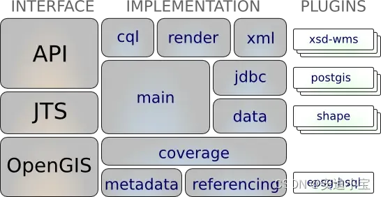
架构图

特性
1. 主要特性
- Geotools主要提供各种GIS算法,实现各种数据格式的读写和显示。
- 在显示方面要差一些,只是用Swing实现了地图的简单查看和操作。
- 用户可以根据Geotools提供的算法自己实现地图的可视化。OpenJump和udig就是基于Geotools的。
- 目前的大部分开源软件,如udig,geoserver等,对空间数据的处理都是由geotools来做支撑。
- web服务,命令行工具和桌面程序都可以由geotools来实现。
- 是构建在OGC标准之上的,是OGC思想的一种实现。而OGC是国际标准,所以geotools将来必定会成为开源空间数据处理的主要工具,
- Geotools用到的两个较重要的开源GIS工具包是JTS和GeoAPI。前者主要是实现各种GIS拓扑算法[只是图形与图形的九交模型并不是图层或图层间的拓扑算法],也是基于GeoAPI的。
- Geotools现在还只是基于2D图形的,缺乏对 3D空间数据算法和显示的支持。
2. Geotools支持的数据格式
arcsde,arcgrid,geotiff,grassraster,gtopo30,image(JPEG,TIFF,GIF,PNG),imageio-ext-gdal,imagemoasaic,imagepyramid,JP2K,matlab;- 支持的数据库“jdbc-ng”:
db2,h2,mysql,oracle,postgis,spatialite,sqlserver; - 支持的矢量格式和数据访问:
app-schema,arcsde,csv,dxf,edigeo,excel,geojson,org,property,shapefile,wfs; XML绑定。基于xml的Java数据结构和绑定提供了如下格式xsd-core(xml simple types),fes,filter,gml2,gml3,kml,ows,sld,wcs,wfs,wms,wps,vpf。对于额外的geometry、sld和filter的编码和解析可以通过dom和sax程序。
3. 支持大部分的OGC标准
- OGC中的sld/SE和渲染引擎;
- OGC一般要素模型包括简单要素支持;
- OGC中栅格信息的网格影像表达;
- OGC中WFS,WMS和额外的WPS;
- ISO 19107 geometry规范;
4. Geotools依赖的开源项目
- JTS:JTS是加拿大的 Vivid Solutions 做的一套开放源码的 Java API。它提供了一套空间数据操作的核心算法,为在兼容OGC标准的空间对象模型中进行基础的几何操作提供2D空间谓词API。
- GeoAPI:GeoAPI为OpenGIS规范提供一组Java接口。
5. GeoTools类库
GeoTools发布的包和其依赖的一些第三方类库总共约有168个,了解GeoTools依赖哪些包和依赖的这些包做什么的,对了解GeoTools这个大家伙一定是有帮助的,具体大家可以下载代码查看,上网搜索一般都能找到一些有用的资料。以下是核心类库的79个jar包:
6. 学习地址
- GeoTools官方网站地址
https://docs.geotools.org/latest/userguide/geotools.html
- GeoTools GitHub地址
https://github.com/geotools/geotools
7. GeoTools的方向
GeoTools GitHub地址
https://github.com/geotools/geotools
常用功能列表
| Module | Purpose |
|---|---|
gt-render | Implements of Java2D rendering engine to draw a map 实现了Java2D的渲染引擎画地图 |
gt-jdbc | Implements for accessing spatial database 实现了访问空间数据库的 |
gt-main | Implements for accessing spatial data 实现对空间数据的访问 |
gt-xml | Implements of common spatial XML formats 实现对共同的xml数据格式的支持 |
gt-cql | Implements of Common Query Language for filters 实现简单语句的查询 |
gt-main | Interfaces for working with spatial information. Implements filter, feature, etc… |
jts | Definition and implementation of Geometry 定义了处理空间信息的接口 |
gt-coverage | Implementation for accessing raster information 实现了Raster数据格式的访问 |
gt-referencing | Implementation of co-ordinate location and transformation 实现了坐标的定义、转换 |
gt-metadata | Implementation of identification and description 元数据的描述和识别 |
gt-opengis | Definition of interfaces for common spatial concepts 定义了空间概念的接口 |
插件
| Module | JAR | Plugin |
gt-render | ||
gt-jdbc | gt-jdbc-db2 | Geometry in DB2 |
gt-jdbc-h2 | Pure Java “H2” database | |
gt-jdbc-mysql | Geometry in MySQL | |
gt-jdbc-oracle | Oracle SDO Geometry | |
gt-jdbc-postgis | PostgreSQL extension PostGIS | |
gt-jdbc-sqlserver | SQL Server | |
gt-jdbc-hana | SAP HANA | |
gt-jdbc-terasdata | Teradata | |
gt-main | gt-shape | Shapefile read/write support |
gt-wfs | WFS read/write support | |
gt-xml | ||
gt-cql | ||
gt-main | ||
jts | ||
gt-coverage | gt-geotiff | GeoTIFF raster format |
gt-arcgrid | arcgrid format | |
gt-mif | MIF format | |
gt-image | JPG, PNG, TIFF formats | |
gt-referencing | epsg-access . | Official EPSG database in Access |
epsg-hsql | Pure Java port of EPSG database | |
epsg-wkt | Lightweight copy of EPSG codes | |
epsg-postgresql | PostgreSQL port of EPSG database | |
gt-metadata | ||
gt-opengis |
扩展
除此之外,GeoTools团队在GeoTools的基础上实现了一些扩展,当然了,这些扩展是为了提供一些额外的功能。这些扩展是相互独立的,我们可以直接在项目中使用。
| JAR | Extension |
|---|---|
gt-graph | Work with graph and network traversals |
gt-validation | Quality assurance for spatial data |
gt-wms | Web Map Server client |
gt-xsd | Parsing/Encoding for common OGC schemas |
gt-brewer | Generation of styles using color brewer |
GeoTools团队为了支持GeoTools中的XML模块,将几个XML模式打包成JAR形式,方便开发者进行调用。
| JAR | Schema |
|---|---|
net.opengis.ows | open web services schema |
net.opengis.wfs | web feature service |
net.opengis.wps | web processing service schema |
net.opengis.wcs | web coverage service schema |
net.opengis.wfs | web feature service schema |
org.w3.xlink | XLink schema |
XSD解析器通过一系列XSD插件使用这些工具。这些插件指示如何使用Eclipse XSD库解析和编码额外的内容来解析XML模式文档,并提供“绑定”,显示如何解析和编码Java类,如String、Date、URL和Geometry。
| JAR | Bindings |
|---|---|
gt-xsd-core | Basic types defined by XML schema |
gt-xsd-fes | filter 2.0 |
gt-xsd-filter | filter (used by OGC CAT and WFS) |
gt-xsd-kml | keyhole markup language |
gt-xsd-wfs | web feature service |
gt-xsd-wps | web processing service |
gt-xsd-gml3 | geographic markup language 3 |
gt-xsd-gml2 | geographic markup language 2 |
gt-xsd-ows | open web services |
gt-xsd-wcs | web coverage service |
gt-xsd-wms | web map service |
gt-xsd-sld | style layer descriptor |
以下是GeoTools不支持的扩展,你也可以使用Maven下载它们来使用。
| Unsupported | Purpose |
|---|---|
gt-swt | Standard widget toolkit interactive map |
gt-swing | Swing interactive map |
gt-oracle | retired oracle support |
gt-postgis | retired PostGIS support |
gt-db2 | retired db2 support |
gt-wps | Web Processing Service client |
gt-process | Job system for spatial data |
geotools引用
maven项目中引用值得注意的地方
1 在pom中配置仓库
<repositories>
    <repository>
      <id>osgeo</id>
      <name>OSGeo Release Repository</name>
      <url>https://repo.osgeo.org/repository/release/</url>
      <snapshots><enabled>false</enabled></snapshots>
      <releases><enabled>true</enabled></releases>
    </repository>
    <repository>
      <id>osgeo-snapshot</id>
      <name>OSGeo Snapshot Repository</name>
      <url>https://repo.osgeo.org/repository/snapshot/</url>
      <snapshots><enabled>true</enabled></snapshots>
      <releases><enabled>false</enabled></releases>
    </repository>
    <!--GeoServer-->
     <repository>
       <id>GeoSolutions</id>
       <url>http://maven.geo-solutions.it/</url>
     </repository>
</repositories>
- 1
- 2
- 3
- 4
- 5
- 6
- 7
- 8
- 9
- 10
- 11
- 12
- 13
- 14
- 15
- 16
- 17
- 18
- 19
- 20
- 21
- 22
2 如果setting中使用了阿里云镜像设置不起作用
<mirror>
<!--该镜像的唯一标识符。id用来区分不同的mirror元素。 -->
    <id>nexus-aliyun</id>
    <!--*指的是访问任何仓库都使用我们的私服-->
     <mirrorOf>*,!osgeo,!GeoSolutions,!osgeo-snapshot,!alfresco</mirrorOf>

    <!--镜像名称-->
    <name>Nexus aliyun</name>
    <!--该镜像的URL。构建系统会优先考虑使用该URL,而非使用默认的服务器URL-->
    <url>http://maven.aliyun.com/nexus/content/groups/public</url>
</mirror>
- 1
- 2
- 3
- 4
- 5
- 6
- 7
- 8
- 9
- 10
- 11
pshot,!alfresco
<!--镜像名称-->
<name>Nexus aliyun</name>
<!--该镜像的URL。构建系统会优先考虑使用该URL,而非使用默认的服务器URL-->
<url>http://maven.aliyun.com/nexus/content/groups/public</url>
- 1
- 2
- 3
- 4
声明:本文内容由网友自发贡献,不代表【wpsshop博客】立场,版权归原作者所有,本站不承担相应法律责任。如您发现有侵权的内容,请联系我们。转载请注明出处:https://www.wpsshop.cn/w/我家自动化/article/detail/591657
推荐阅读
相关标签


