- 1基于PHP+Mysql+Html公司企业产品网站系统设计与实现 开题报告参考
- 2如何解决phpmyadmin提示在服务上检测到错误_phpmyadmin导出sql为什么提示请检查互联网状况
- 3linux环境下,一步步教你命令行搭建自己的git服务器和客户端_linux git服务器搭建
- 4ubuntu下openvino 目录(Pip安装openvino)_pip install openvino
- 5k8s基础5——Pod常用命令、资源共享机制、重启策略和健康检查、环境变量、初始化容器、静态pod_k8s pod 启不来 使用command sleep
- 6unity-VRTK学习日记1(VRTK4|无头盔开发模拟器SpatialSimulator)_unityvr模拟器
- 7基于Python分析气象数据教程-2_python 气象数据机器学习
- 8Axure RP9入门介绍----小白
- 9基本架构:一个键值数据库包含什么?_数据库键值对
- 10华为OD机试 - 开源项目热度榜单(Java & JS & Python & C & C++)_华为od 开源项目热度榜单
在ArcMap 10.2中进行了坐标系定义和投影转换后,若干图层在放大到某一比例尺时不再显示的问题_定义完投影图层不显示
赞
踩
莫名其妙的某个图层放大到1:20000以上后不显示,
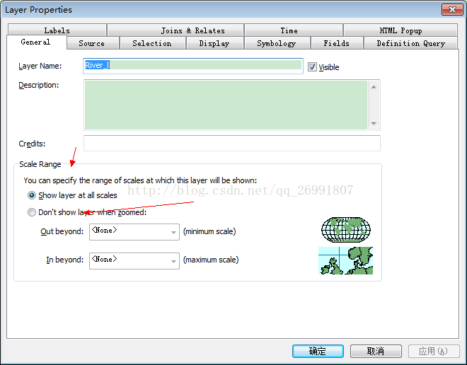
1.首先想到的应该是scales range的范围是不是被限制了,如图一所示,但是我的设置的为show All scales,经过重新设置显示范围和在此设为ALL scales 仍然不奏效,
图1
2.坐标系统也不存在问题,几个图层都是在同一个投影坐标系下,数据框的坐标系也一致,full ZOOM也很正常,后来觉得可能是盗版软件的问题,于是经过将图层删除,然后再进行添加图层。在同时添加图层过程中,窗口弹出了以下一个警告
Warning, inconsistent extent!
One or more of the added layers has an extent that is not consistent with the associated spatial reference information.
Re-projecting that data in such a layer may lead to unexpected behaviour
说是可能是多次投影导致了图层范围与空间参考信息不匹配,然后跑去查看图层文件中的extent发现本来应该是相同范围的图层中extent中的各种参数确实不一样。网上说去catalog中先清除坐标系,再重新投影,但是我10.2中并没有找到,网上所说的 “在catalog里选中要操作的文件右键-properties-spatial reference 边上的edit---clear先前的投影信息” spatial reference 、edit、clear选项。可能是版本不一样吧。
后来在外国网站上找到了相应的问题,他们提供了三种方法:这也是其中一种,
3.最后我通过导出exportdata,然后在add data添加导出的feature回地图中解决了不显示的问题。
参考链接:点击打开链接;https://gis.stackexchange.com/questions/159809/projected-raster-data-has-inconsistent-extent-but-not-shapefile


