热门标签
热门文章
- 1Spring boot 发送文本邮件 和 html模板邮件
- 2【Linux】SSH协议应用
- 3尚硅谷微信小程序开发 仿网易云音乐App 小程序 后端接口服务器搭建_微信小程序网易云接口
- 4vue-cli打包问题_打包报错vue cli build failed. please resolve any issue
- 5速成版-带您2天学完vue3框架+Element-plus框架_vue+element-plus
- 6Transformer 源码复现杂记
- 7利用HTML5与CSS实现新闻网页设计_新闻网页设计代码
- 8C语言简单游戏编程入门之四子棋_c语言四子棋
- 99.7. 序列到序列学习(seq2seq) 实现机器翻译 英语翻译法语_for param in m._flat_weights_names:
- 10改进YOLO系列:YOLOv8增加小目标检测层(可自适应调节网络宽度和深度),提高对小目标的检测效果_小样本学习适合yolov8么
当前位置: article > 正文
QGIS添加在线底图_openwhatevermap
作者:2023面试高手 | 2024-03-29 16:04:38
赞
踩
openwhatevermap
0 前言
一般的GIS软件都可以添加在线底图,运动软件也能添加在线底图。
在ArcMap中可以添加在线底图,不过em用户体验还是差点意思。
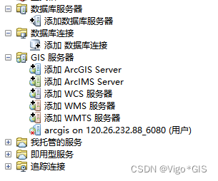
ArcGIS Pro中也可以添加在线底图,具体操作步骤可参考文章ArcGIS Pro添加在线底图
ArcGIS Pro的在线底图种类繁多,品种丰富,使用体验非常nice,但毕竟是商业软件,很多同学可能无法负担得起。
这时候就不得不说一下QGIS及在线底图了,QGIS的在线底图添加方便,图源众多,基本上主流的地图都有,不管是Esri还是Google出品的地图,还有OSM等,卫星图、街景图、地质图等等。
下面我将详细介绍一下如果在QGIS中添加在线底图
1 寻找在线底图链接
在网站http://openwhatevermap.xyz/#3/28.00/18.00中,可以找到非常多类型的在线底图,点击其中一个即可查看链接
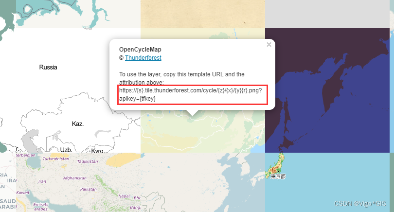
2 常见的在线底图及其链接
Google_Maps: https://mt1.google.com/vt/lyrs=r&x={x}&y={y}&z={z}
Google_Terrain: https://mt1.google.com/vt/lyrs=t&x={x}&y={y}&z={z}
Google_Roads:https://mt1.google.com/vt/lyrs=h&x={x}&y={y}&z={z}
Google_Satellite: https://mt1.google.com/vt/lyrs=s&x={x}&y={y}&z={z}
Google_Streets:https://mt1.google.com/vt/lyrs=m&x={x}&y={y}&z={z}

cartocdn_dark_nolabel:http://basemaps.cartocdn.com/dark_nolabels/{z}/{x}/{y}.png
cartocdn_light_nolabels:http://basemaps.cartocdn.com/light_nolabels/{z}/{x}/{y}{r}.png
cartocdn_voyager_nolabels:https://basemaps.cartocdn.com/rastertiles/voyager_nolabels/{z}/{x}/{y}.png

ESRI_World_Imagery:https://server.arcgisonline.com/ArcGIS/rest/services/World_Imagery/MapServer/tile/{z}/{y}/{x}
ESRI_World_Light_Gray_Base:https://server.arcgisonline.com/ArcGIS/rest/services/Canvas/World_Light_Gray_Base/MapServer/tile/{z}/{y}/{x}
ESRI_World_Topo_Map:https://server.arcgisonline.com/ArcGIS/rest/services/World_Topo_Map/MapServer/tile/{z}/{y}/{x}

memomaps_tilegen:http://tileserver.memomaps.de/tilegen/{z}/{x}/{y}.png

openstreetmap:https://tile.openstreetmap.org/{z}/{x}/{y}.png
openstreetmap_br:https://tile.openstreetmap.bzh/br/{z}/{x}/{y}.png
openstreetmap_cyclosm:https://a.tile-cyclosm.openstreetmap.fr/cyclosm/{z}/{x}/{y}.png
openstreetmap_hot:https://a.tile.openstreetmap.fr/hot/{z}/{x}/{y}.png

stamen_terrain:http://a.tile.stamen.com/terrain/{z}/{x}/{y}.png
stamen_terrain_background:http://a.tile.stamen.com/terrain-background/{z}/{x}/{y}.png
stamen_terrain(高清):http://a.tile.stamen.com/terrain/{z}/{x}/{y}@2x.png
stamen_watercolor:https://stamen-tiles-c.a.ssl.fastly.net/watercolor/{z}/{x}/{y}.jpg
staman水彩图:http://a.tile.stamen.com/watercolor/{z}/{x}/{y}.jpg

thunderforest_cycle:https://tile.thunderforest.com/cycle/{z}/{x}/{y}.png?apikey=
thunderforest_pioneer:https://tile.thunderforest.com/pioneer/{z}/{x}/{y}.png?apikey=

wmflabs_bw_mapnik:http://tiles.wmflabs.org/bw-mapnik/{z}/{x}/{y}.png

高德:https://blog.csdn.net/ldlzhy1984/article/details/81015180
https://blog.csdn.net/fredricen/article/details/77189453
高德矢量图:https://webrd02.is.autonavi.com/appmaptile?lang=zh_cn&size=1&scale=1&style=8&x={x}&y={y}&z={z}
高德遥感图:http://webst02.is.autonavi.com/appmaptile?style=6&x={x}&y={y}&z={z}


Mapbox底图:https://api.mapbox.com/styles/v1/mapbox/streets-v10/tiles/256/{z}/{x}/{y}?access_token=<mapbox key>

天地图矢量图:https://t6.tianditu.gov.cn/vec_w/wmts?SERVICE=WMTS&REQUEST=GetTile&VERSION=1.0.0&LAYER=vec&STYLE=default&TILEMATRIXSET=w&FORMAT=tiles&TILECOL={x}&TILEROW={y}&TILEMATRIX={z}&tk=<tianditu key>
天地图矢量注记:https://t2.tianditu.gov.cn/cva_w/wmts?SERVICE=WMTS&REQUEST=GetTile&VERSION=1.0.0&LAYER=cva&STYLE=default&TILEMATRIXSET=w&FORMAT=tiles&TILECOL={x}&TILEROW={y}&TILEMATRIX={z}&tk=<tianditu key>
天地图遥感图:https://t3.tianditu.gov.cn/img_w/wmts?SERVICE=WMTS&REQUEST=GetTile&VERSION=1.0.0&LAYER=img&STYLE=default&TILEMATRIXSET=w&FORMAT=tiles&TILECOL={x}&TILEROW={y}&TILEMATRIX={z}&tk=<tianditu key>
天地图遥感注记:https://t2.tianditu.gov.cn/cia_w/wmts?SERVICE=WMTS&REQUEST=GetTile&VERSION=1.0.0&LAYER=cia&STYLE=default&TILEMATRIXSET=w&FORMAT=tiles&TILECOL={x}&TILEROW={y}&TILEMATRIX={z}&tk=<tianditu key>

WMTS:
Mapbox:https://api.mapbox.com/styles/v1/mapbox/streets-v11/wmts?access_token=<mapbox key>

WFS:
天地图:http://gisserver.tianditu.gov.cn/TDTService/wf
- 1
- 2
- 3
- 4
- 5
- 6
- 7
- 8
- 9
- 10
- 11
- 12
- 13
- 14
- 15
- 16
- 17
- 18
- 19
- 20
- 21
- 22
- 23
- 24
- 25
- 26
- 27
- 28
- 29
- 30
- 31
- 32
- 33
- 34
- 35
- 36
- 37
- 38
- 39
- 40
- 41
- 42
- 43
- 44
- 45
- 46
- 47
- 48
- 49
- 50
- 51
3 在QGIS中添加在线底图
-
打开
XYZ Tiles
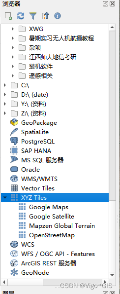
-
右键新建连接
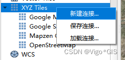
-
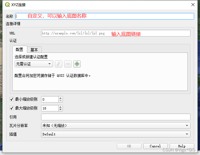
在下面的框中的名称中输入底图名称(可自定义),在URL后面的框中输入在线底图的链接
-
将在线底图添加进主窗口中
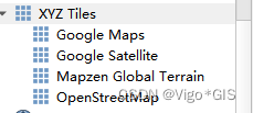
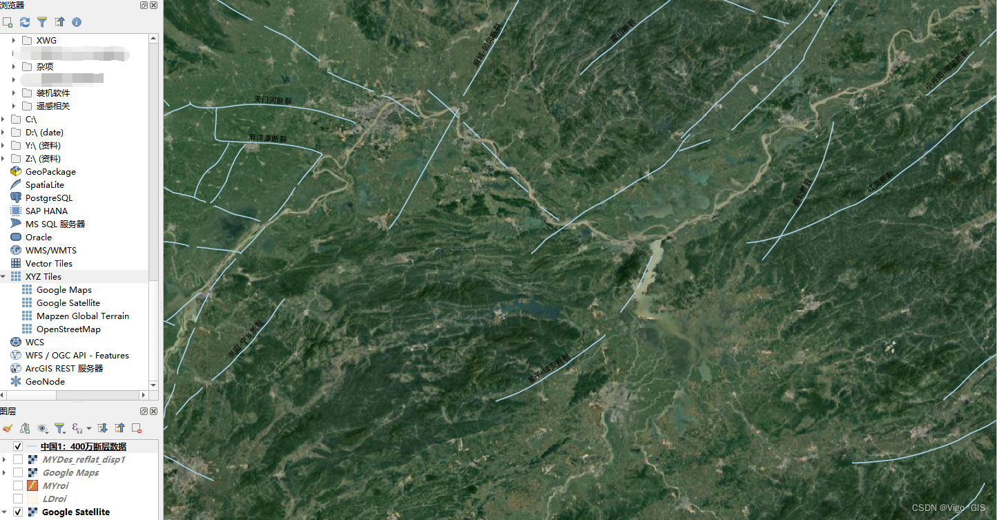
直接用鼠标拖进去即可,下图是将断层数据上置Google卫星底图
感谢阅读!
声明:本文内容由网友自发贡献,不代表【wpsshop博客】立场,版权归原作者所有,本站不承担相应法律责任。如您发现有侵权的内容,请联系我们。转载请注明出处:https://www.wpsshop.cn/w/2023面试高手/article/detail/336032
推荐阅读
相关标签


